News

Welcome to OGC News. You can use the filter below to show only Calls For Participation in or Sponsorship of OGC Initiatives, Requests for Public Comment, General Press Releases, or Blog Posts. Or use the search box to find news on a specific topic.

You may also want to subscribe to the OGC Newsletter: a short digest of news and events sent every two weeks.

All news (1453 match criteria)

OGC announces virtualcitySYSTEMS as the winner of the 2019 OGC CityGML Challenge

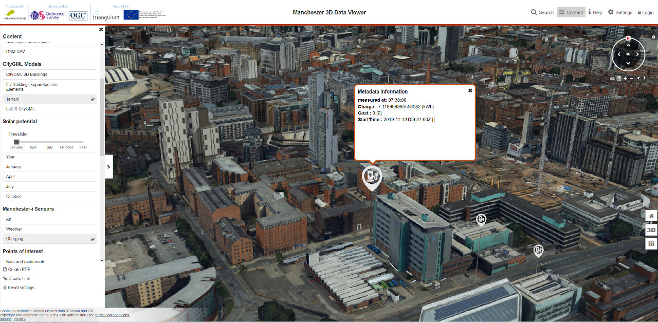
The Manchester 3D Data Viewer was developed by virtualcitySYSTEMS as the winning entry to the 2019 CityGML Challenge.OGC’s CityGML standard is an open data model and format for the storage and exchange of virtual 3D city models.“To be part of this OGC challenge was truly challenging, but a wonderful experience.About OSOrdnance Survey (OS) is the national mapping agency for Great Britain, and a world-leading geospatial data and technology organisation.The Manchester partners are the University of Manchester, Manchester Metropolitan University, Siemens, local SME, Pixel Mill Digital, and Manchester City Council.

OGC announces virtualcitySYSTEMS as the winner of the 2019 OGC CityGML Challenge

The winning spot was awarded for creating the CityGML 3 visualization tool with the most comprehensive data integration environment, 3D analysis tools, and integration of other standards.

Linda van den Brink receives OGC’s 2019 Gardels Award

Congratulations to Linda van den Brink, awarded the 2019 Gardels Award for being “an outstanding representative both internal to OGC and external.”Linda van den Brink (left) receives the 2019 OGC Gardels Award from OGC President Bart De Lathouwer (right)Last night, at the November meeting of the Open Geospatial Consortium (OGC) Technical Committee in Toulouse, France, Linda van den Brink received the OGC’s prestigious Kenneth D. Gardels Award.The Gardels Award is presented each year to an individual who has made an outstanding contribution to advancing OGCs vision of using location to connect people, communities, technology, and decision making for the greater good.Linda van den Brink was awarded because of her effective coordination between the OGC and other standards and industry bodies.As noted by one of the nominating committee: “Linda has been an outstanding representative both internal to OGC and external.“I’m very happy that Linda van den Brink has received the 2019 Gardels Award,” commented Bart De Lathouwer, President of OGC.

ESIP and OGC invite you to the Coverage Processing and Analysis API Sprint

This will be a key event in the development of OGC APIs for geospatial resources and building blocks for community APIs.The Coverage Processing and Analysis API Sprint will be co-located with the 2020 ESIP Winter Meeting, which draws Earth Science data and information professionals from across the public, private, and academic sectors.By developing prototype functionality through running code, the sprint will assess and advance draft versions of OGC API – Coverage, OGC API – Process and OGC API – Common standards.The OGC API – Coverages places the semantics of the Geospatial Coverages into an OpenAPI resource-oriented approach.OGC API – Coverages needs to be extended to include methods for analytics.

ESIP and OGC invite you to the Coverage Processing and Analysis API Sprint

Agile development sprint will advance APIs for analytics on coverages, arrays, and gridded data.

OGC Renews Memorandum Of Understanding With FrontierSI

OGC and FrontierSI continue to work together to reach out, innovate, and educate at national, regional, and international levels.The Open Geospatial Consortium (OGC) announces that it has re-signed a Memorandum of Understanding with Australian geospatial not-for-profit, FrontierSI.FrontierSI is is a partner-based research organisation with expertise in positioning, geodesy, spatial infrastructures, and rapid spatial analytics.OGC’s member-driven consensus process creates royalty free, publicly available geospatial standards.OGC is committed to creating a sustainable future for us, our children, and future generations.

OGC Renews Memorandum Of Understanding With FrontierSI

OGC and FrontierSI continue to work together to reach out, innovate, and educate at national, regional, and international levels.

OGC Pilot Initiative seeks to advance the state of the art in UML-to-GML Application Schema (UGAS) transformations and related technologies; funding available for participants

The OGC UML-to-GML Application Schema Pilot 2020 (UGAS-2020) will improve and enhance the present capabilities of the open source tool ShapeChange in order to meet current and emerging technology requirements.The Open Geospatial Consortium (OGC) has released a Call For Participation in the OGC UML-to-GML Application Schema Pilot 2020 (UGAS-2020) and is offering funding for interested participants.The goal of this Pilot is to advance the “state of the art” in UML-to-GML Application Schema (UGAS) transformations and related technologies.Under OGC’s Innovation Program, sponsors and OGC members come together to address geospatial IT challenges in an agile and cooperative manner.OGC members together form a global forum of experts and communities that use location to connect people with technology and improve decision-making at all levels.

OGC Pilot Initiative seeks to advance the state of the art in UML-to-GML Application Schema (UGAS) transformations and related technologies; funding available for participants

The OGC UML-to-GML Application Schema Pilot 2020 (UGAS-2020) will improve and enhance the present capabilities of the open source tool ShapeChange in order to meet current and emerging technology requirements. 

Sign up today

Receive the latest news on OGC.

© 2024 Open Geospatial Consortium. All Rights Reserved.

Become a memberBecome a member