News

Welcome to OGC News. You can use the filter below to show only Calls For Participation in or Sponsorship of OGC Initiatives, Requests for Public Comment, General Press Releases, or Blog Posts. Or use the search box to find news on a specific topic.

You may also want to subscribe to the OGC Newsletter: a short digest of news and events sent every two weeks.

All news (1453 match criteria)

OGC announces exciting agenda for two-day Location Powers: Data Science summit

Location Powers: Data Science will be held 13-14 Nov at Google’s Crittenden Campus in Mountain View, CAThe Open Geospatial Consortium (OGC) has announced the agenda for its Location Powers: Data Science summit.Wendy will present the keynote of Session 4: Outcomes, which concerns the application of geospatial data science.The Location Powers: Data Science Summit will convene experts on data science, machine learning, artificial intelligence, cloud computing, remote sensing, and Geographic Information Systems (GIS) to provide a technology basis.The workshop will conclude with recommendations on how to advance geospatial data science in theory and practice.Currently we are in an age of data abundance and highly available computing resources – a golden age of data science.

GeoTIFF v1.1 adopted as an OGC Standard

The GeoTIFF 1.1 standard formalizes the existing GeoTIFF specification version 1.0 by integrating it into OGC’s standardization process.Approval of this GeoTIFF 1.1 standard begins the process of integration of the GeoTIFF standard into other parts of OGC’s standardization process.The Libgeotiff development version (future version 1.6.0) and the GDAL development version (future version 3.1.0) both support this GeoTIFF 1.1 version.As with any OGC standard, the open GeoTiff 1.1 standard is free to download and implement.Interested parties can view and download the standard on the OGC’s GeoTIFF Standard Page.

CityGML-Urban Planning ADE Ideathon will be held in Japan

In October and February, the Ideathon will discuss expanding the applications of CityGML and Urban Planning ADE in Japan, as well as the demand for updated versions in the future.The Open Geospatial Consortium (OGC), in collaboration with the Cabinet Office of Japan, the Ministry of Land, Infrastructure, Transport and Tourism (MLIT) of Japan, and the Urban Structure Visualization Promotion Organization (USVPO), are pleased to announce the CityGML-Urban Planning ADE Ideathon held across two two-day meetings in Japan.In addition, participants of the 1st Ideathon session may report on use cases of CityGML and the Urban Planning ADE.For more information about the Ideathon, please visit the CityGML-Urban Planning ADE Ideathon event page.Participants will discuss the implementation of the Urban Planning ADE, announced on May 7, 2019.

OGC Invites Participants to Help Advance Vector Tiles Interoperability

Vector Tiles Pilot, Phase 2 will advance interoperability for vector tiles using established OGC standards and the latest OGC APIs – and help geospatial enterprises create custom maps for seamless online/offline use.After a successful Vector Tiles Pilot in 2018, the Open Geospatial Consortium (OGC) invites developers to its Vector Tiles Pilot, Phase 2 (VTP-2).Under OGC’s Innovation Program, sponsors and OGC members come together to address geospatial IT challenges in an agile and cooperative manner.More information on the Pilot, including the Call for Participation, is available on the OGC Vector Tiles Pilot Phase 2 Initiative Webpage.OGC members together form a global forum of experts and communities that use location to connect people with technology and improve decision-making at all levels.

OGC DGGS Standards Working Group seeks public comment on new tasks of work added to its charter

The Discrete Global Grid Systems SWG will work with relevant working groups as necessary to embed linkages between DGGS and other standards in the OGC Standards baseline.The Open Geospatial Consortium (OGC) seeks public comment on new work tasks added to the charter of the Discrete Global Grid Systems (DGGS) Standards Working Group (SWG).However, the fundamental and cross-cutting nature of DGGS resulted in the OGC DGGS being published as an OGC Abstract Specification that defines a conceptual model.The DGGS SWG is therefore working with relevant OGC Working Groups as necessary to embed linkages between DGGS and other standards in the OGC Standards baseline.Comments are due by 26th September, 2019 and should be submitted via the method outlined on the Discrete Global Grid Systems Standards Working Group Charter request page.

OGC announces next Location Powers Summit, focused on Data Science

Location Powers: Data Science will be held 13-14 Nov at Google’s Crittenden Campus in Mountain View, CAThe Open Geospatial Consortium (OGC) invites you to its next Location Powers summit, which will focus on Data Science.The workshop will conclude with recommendations on how to advance geospatial data science in theory and practice.The explosive availability of data about nearly every aspect of human activity, coupled with rapid advances in computing technologies, is transforming data science.Currently we are in an age of data abundance and highly available computing resources – a golden age of data science.The Location Powers: Data Science Summit will convene experts on data science, machine learning, artificial intelligence, cloud computing, remote sensing, and Geographic Information Systems (GIS) to provide a technology basis.

The Industrial Internet Consortium and the Open Geospatial Consortium Announce Liaison

Organizations will work together to help further IoT industry market adoptionThe Open Geospatial Consortium (OGC) and the Industrial Internet Consortium® (IIC™) announce they have agreed to a liaison to work together to advance their shared interests.About the Industrial Internet ConsortiumThe Industrial Internet Consortium is the world’s leading membership program transforming business and society by accelerating the Industrial Internet of Things (IIoT).The Industrial Internet Consortium is a program of the Object Management Group (OMG).About OGCThe Open Geospatial Consortium (OGC) is an international consortium of more than 530 businesses, government agencies, research organizations, and universities driven to make geospatial (location) information and services FAIR – Findable, Accessible, Interoperable, and Reusable.Note to editors: Industrial Internet Consortium is a registered trademark of OMG.

OGC hosts successful launch of Smart Cities Tech Pilot

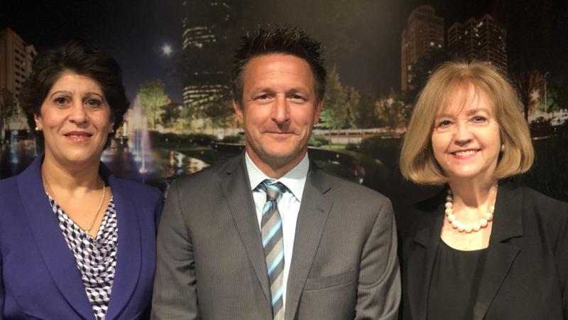
SCIRA Pilot will help bring smart cities standards to the public safety community in the US and around the world.The intended outcome of this smart city effort is to enhance public safety by creating efficient and effective operations across all city departments.“The City of St. Louis joined the federal Smart Cities Initiative in an effort to improve public safety, among other objectives.I am excited to be partnering with DHS S&T and OGC on this very important smart city effort,” Mayor Lyda Krewson said.Through the SCIRA project’s findings, cities could have open, interoperable methods for incorporating smart city technologies across city services using shared technology standards.

OGC hosts successful launch of Smart Cities Tech Pilot

Left to right: Nadine Alameh, OGC CEO; Norman Speicher, Program Manager / Computer Scientist at DHS S&T; and Mayor Lyda Krewson, Mayor of the City of St. Louis, at the Launch of the PIlot.

Sign up today

Receive the latest news on OGC.

© 2024 Open Geospatial Consortium. All Rights Reserved.

Become a memberBecome a member